
Winter Is Not Done With North Dakota Yet; Winter Weather Advisory for Bismarck
It'll be back to work on Monday, but old man winter is not quite done with North Dakota yet as the National Weather Service in Bismarck has issued a mixed bag of advisories for the entire state.
As Monday (March 6th) progresses, the day will deteriorate with wintery conditions. Therefore the National Weather Service in Bismarck has issued an Winter Weather Advisory starting at 11 a.m. CST, Monday. A wintry mix of light freezing rain, sleet and snow will develop across western and north central North Dakota late tonight and early
Monday morning, changing over to all snow through the day Monday.
Precipitation should begin as rain along and east of a line from
Bottineau to Bismarck Monday morning, with the wintry mix developing
Monday afternoon and changing over to all snow by Monday evening.
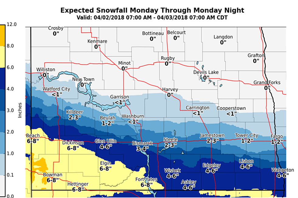
Snow totals will vary depending on where you are, or where you could be traveling to. Areas around Bottineau and Rolette counties south to McHenry and Pierce
counties could receive as much as 8 inches. Locally, in our region, the snow fall will vary from less than an inch to up to 3 inches.
To add insult to injury to add to the fresh snow, northwest winds of around 35 mph with gusts to 50 mph are expected to develop on Monday causing blowing and drifting snow.
Stay on top of this changing weather pattern as the work week begins.
More From 96.5 The Walleye